Balado vidéo
Le chemin du Treizième-Rang
Ce chemin est une route de sept kilomètres reliant la rue des Pins de Magog au chemin Alfred-Desrochers d’Orford. Il se divise en deux, la partie sud d’environ deux kilomètres traverse en diagonale les anciens lots du rang XIII, à l’est de Cherry River. À la sortie de la dernière courbe, la partie nord devient un chemin droit jusqu’à la fin. Cette section droite se trouve exactement sur la ligne de division entre les rangs XIII à l’ouest et XII à l’est, desservant ainsi les deux rangs.
Au milieu de cette section droite, on arrive sur un plateau élevé entre les bassins versants de la branche de l’Est de la rivière aux Cerises à l’ouest et du ruisseau Rouge à l’est. On peut y contempler de très belles vues du mont Orford.
On trouve cette appellation de « chemin du treizième rang » dans des actes notariés d’avant 1900. Au milieu des années 1890, dans la partie sud, des habitants de Cherry River acquièrent des lots de la British American Land Company (BALC). Cette partie du rang XIII est un secteur d’expansion tout naturel pour les jeunes ménages des environs, majoritairement anglophones.
La section nord fut probablement d’abord un chemin de bois. Au début des années 1900, la Prouty & Miller (P&M), une compagnie d’exploitation forestière qui possède une importante scierie à Newport (Vermont), achète de la BALC tous les lots à l’est du chemin. Du côté ouest, la P&M acquière les terres via quelques intermédiaires, principalement Arthur J. Whitehead (lumber dealer de Eastman) et Gilbert Morier (commerçant de Magog). Ces derniers détiennent des billets d’occupation (promesses de vente) ou ont acheté de la BALC.
Pendant l’exploitation forestière par la P&M, dès le début des années 1900, des ménages s’installent le long du chemin. Au recensement de 1911, toute la partie haute du chemin sera occupée par une vingtaine de ménages, tous avec des noms français et de religion catholique. Ce sont sans doute des bûcherons et des colons qui ont obtenu des baux ou des promesses de vente de la P&M ou de quelques investisseurs immobiliers. Quant à la P&M, elle vendra progressivement ses lots de 1920 à 1940.
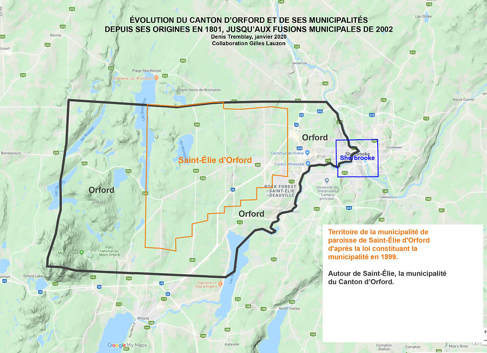
En 1899, cette partie nord fut détachée du canton d’Orford pour être annexée à la municipalité de paroisse de Saint-Élie-d’Orford. Plus de 100 ans plus tard, elle reviendra à la municipalité du Canton d’Orford, au moment de la réorganisation et des fusions municipales de 2002.

Podcast video
The Treizième-Rang Road
This road is a seven kilometre artery connecting the Rue des Pins in Magog to Alfred-Desrochers in Orford. It consists of two portions. East of Cherry River the approximately two kilometres of the southern part crosses, on the diagonal, several lots of what was the XIIIth range. After one last bend, the northern part then follows a straight line that tracks exactly the demarcation between the XIIth range, to the east, and the XIIIth on the west side of the road. As such, it could effectively serve settlers on both ranges.
In the middle of the straightaway, a high plateau is the watershed between the East Branch of the rivière aux Cerises to the west and the ruisseau Rouge to the east. The height of land provides wonderful views of Mount Orford.
Notary documents dating from before 1900 show that this name for the road was already in use. By the mid-1890s, some residents of Cherry River were taking up British American Land Company (BALC) lots along the southern portion. This part of the XIIIth range was an obvious direction of movement for the village’s young households, mostly Anglophone.
The northern portion began as a logging road. Prouty and Miller (P&M) was a lumber company with a major sawmill in Newport, Vermont. Early in the 1900s, the BALC sold P&M all the land on the eastern side of the road. On the other side, P&M acquired the land from several intermediaries, primarily Arthur J. Whitehead, a lumber dealer from Eastman, and Gilbert Morier, a Magog trader. The two had held location tickets (promises of sale) or had obtained the land from the BALC.
From the first years of the 1900s and while P&M was logging, settlement occurred along this portion of the road. The 1911 Census shows there were about 20 households, all with French names and identifying as Roman Catholic. No doubt, they were loggers or settlers who had obtained leases or promises of sale from P&M or land speculators. P&M concluded the final sales of its lots between 1920 and 1940.
At the time, however, these residents were no longer citizens of Canton d’Orford. In 1899, the new municipality of the Parish of Saint-Élie-d’Orford annexed the territory served by the northern portion of the road. It took more than 100 years and the municipal reorganization and fusions of 2002 before it returned to Orford.